Follow us


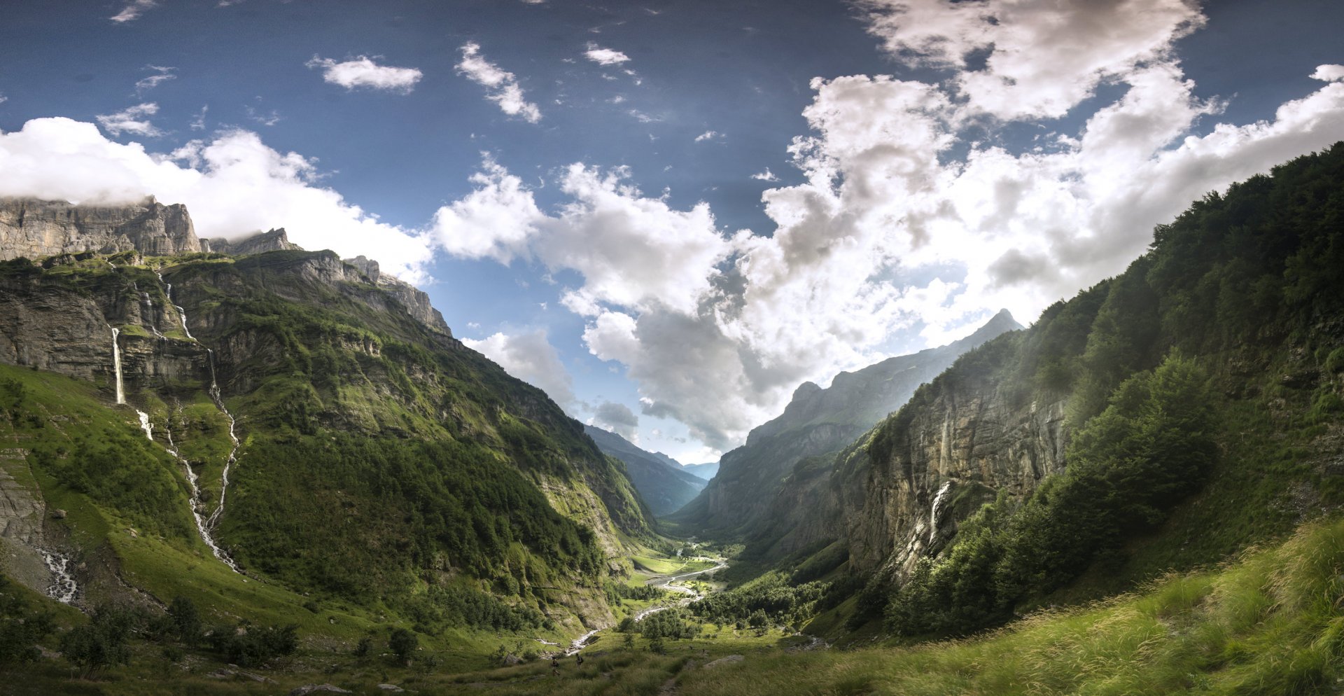
Authentic hiking Around the Dents Blanches
Duration:
7 days
Price from: 1 045€
Fitness:

Infobulle physique
Physical Level 1: For individuals who engage in occasional physical activity, positive elevation gain up to 250m or distance up to 5km.
Physical Level 2: For individuals who engage in regular physical activity, positive elevation gain up to 500m or distance up to 10km.
Physical Level 3: For individuals who engage in regular endurance activities, positive elevation gain up to 1000m or distance up to 20km or multi-day routes with carrying personal belongings for the day.
Physical Level 4: For individuals who engage in regular endurance activities, positive elevation gain up to 1400m or distance up to 25km or multi-day routes with carrying personal belongings for the duration of the trek.
Physical Level 5: For individuals who engage in intensive endurance activities, positive elevation gain exceeding 1400m or distance exceeding 25km.
Technique:
Infobulle technique
Technical Level 1: For walkers, capable of navigating wide mountain trails suitable for vehicles.
Technical Level 2: For occasional hikers, capable of navigating non-technical mountain trails.
Technical Level 3: For regular hikers, capable of navigating slightly uneven mountain trails with roots or rocks.
Technical Level 4: For experienced hikers, capable of navigating rugged mountain trails with boulders, large steps, or exposed sections.
Technical Level 5: For seasoned hikers, capable of navigating off-trail routes or mountain trails with equipped sections, such as cables or ladders.
Comfort :


Level 1. The comfort of your stay is minimalist. You sleep in a tent and carry your personal belongings throughout the stay.
Level 2. The comfort of your stay is limited. You mostly sleep in refuges or hostels, in dormitories, and carry your personal belongings throughout the stay.
Level 3. The comfort of your stay is intermediate. You mostly sleep in refuges, hostels, or hotels, in dormitories. Assistance is provided for the transport of your personal belongings, when possible.
Level 4. The comfort of your stay is high. You mostly sleep in hotels, in rooms. Assistance is provided for the transport of your personal belongings, when possible.
Level 5. The comfort of your stay is very high. You mostly sleep in 3- or 4-star hotels in rooms. Assistance is provided for the transport of your personal belongings, when possible.
General information
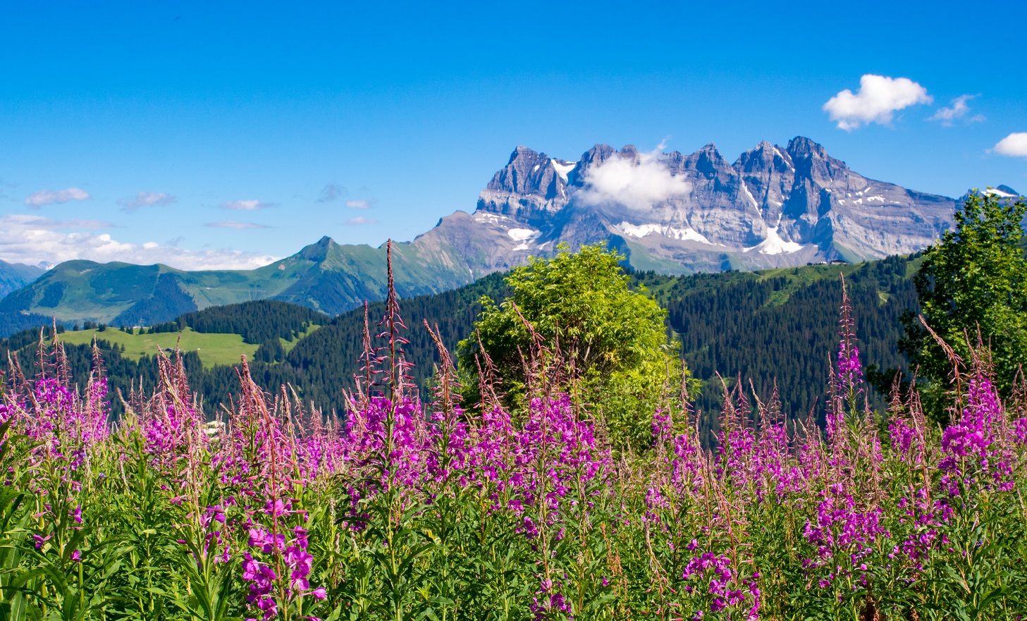
This hike is intended for experienced hikers and will satisfy the adventurer within you. Wild and preserved, this varied and maintained route is unique and exclusive to the Compagnie des Guides de Chamonix. This trip takes place to the north of the Mont-Blanc massif, between France and Switzerland. Using hidden away trails, we will discover rich and sumptuous landscapes and discover the varied histories of the numerous valleys we will cross through.
Benefit from the knowledge of our mountain leaders without worrying about the logistics. You carry your weekly belongings in your backpack to fully enjoy the mountains. Accommodation in hostels or refuges. Nights in dormitories. We use the local transport for the transfers and supplies are obtained in either the mountain villages or at the accommodation.
Group booking
Group session associate several people who don't know each other. It allows for a planned program to benefit from an attractive price on fixed dates. This formula is ideal for people looking for the friendliness of a group.
Dates : See below for the group booking module
Price 2026 : 1045 € per person based on minimum 6 participants
The price includes:
- The organization of the trip
- the supervision by a state qualified trekking guide
- half-board accommodation in refuges sleeping in mixed dormitories
- picnic lunches
- Return transfer by train from Chamonix to le Buet hamlet
This price does not include:
- Transportation to the starting point of the hike
- Accommodation before and after the hike
- Personal expenses: souvenirs, drinks, etc.
- Ski lifts or taxi transfers in case of personal inability to complete the planned stage
- Mandatory repatriation insurance. Cancellation insurance is strongly recommended. (Residents of the following countries—Andorra, Austria, Belgium, Denmark, Finland, France, Germany, Gibraltar, Greece, Ireland, Italy, Liechtenstein, Luxembourg, Monaco, Netherlands, Norway, Portugal, San Marino, Spain, Sweden, Switzerland, and the United Kingdom—can purchase repatriation and cancellation insurance at the same time as their trip registration. This insurance is non-refundable in case of cancellation.)
- Booking fees
- Anything not mentioned under "This price includes"
Private booking
Want to go hiking with family or friends? Want the freedom to choose your departure dates*, enjoy a tailor-made itinerary adapted to your desires, and benefit from guidance specifically suited to your level? Choose the private package!
This is the traditional relationship between a guide and their clients. It allows you to be alone or in a group with your guide, who will respond to your specific needs. The ideal package for realizing your plans, as it guarantees maximum comfort.
Discounted rates based on the number of participants.
*Subject to availability of accommodation.
Contact us for a quote.
Further information
In this section, find all the information about this activity. For further information, please contact our advisor (contact details above).
Meeting point : Meet at 7.30am at the Compagnie des Guides office, 190 Place de l’Eglise, 74400 Chamonix. We will take the train to le Buet hamlet where our hike will start.
Ability level : 5/5 - The Dents Blanches hiking trip is a strenuous and demanding trek. More than 1000m (3,280ft.) vertical gain and about 7 to 9 hours of daily hiking. Some days may be long and demanding, involving altitude and High Mountain passes (min. 9 190ft.). Hiking on mountain trails and terrain showing exposed and difficult sections. These trips generally require carrying a backpack with personal belongings throughout the trek. For very active, well-trained people with a solid experience in alpine trekking.
Itinerary: The guide may need to adjust the itinerary based on weather conditions and/or the physical and/or technical abilities of the group.
Guiding policy : maximum 12 people per guide. The Compagnie des Guides de Chamonix's guiding policy is one of the strictest in the mountain guiding business. It guarantees the most balanced groups as possible as well as high-quality personalised advice.
Important: Registration possible from 16 years of age. Registration is not permitted to anyone under the age of 18 without a legal guardian.
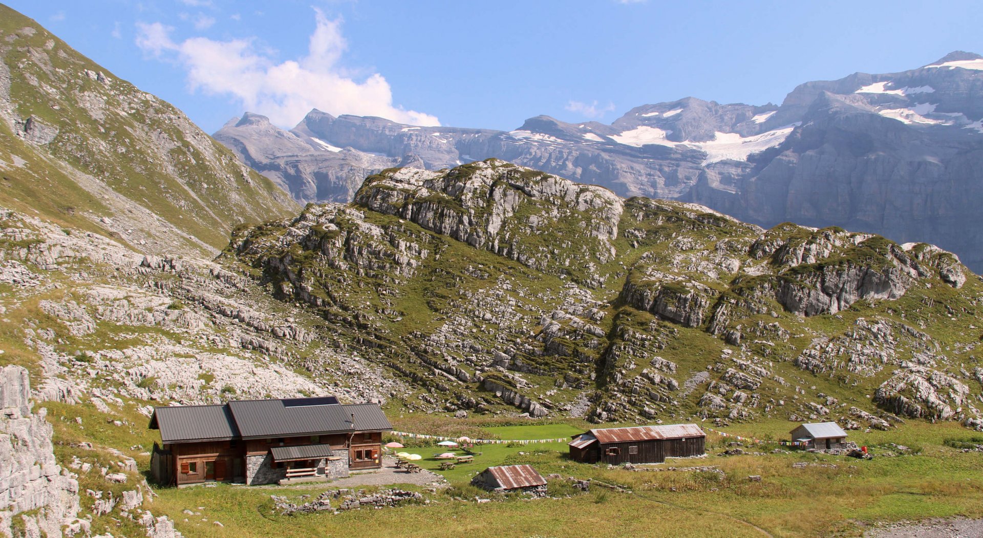
Accommodation :
- During the trip : 6 nights half board in mixed dormitories. No shower at Vieux Emosson mountain hut. Each hiker carries all their personal belongings and picnic for the entire trek.
- Before & after the trip : benefit from preferential prices from our partner hotels in Chamonix. If you wish to receive information just ask the Randonnée department.
Documentation :
- Participants must have sports insurance with repatriation cover. We strongly recommend that this also includes cancellation cover. You can take out insurance offering both of these types of cover when you sign up.
- Participants must also take valid ID with them.
Preparing for the trip : There is an information meeting with your mountain leader the day before departure at 6pm at the Compagnie des Guides Office.
Equipment
Weight is a hiker's adversary, so it is crucial to carefully select your equipment as it plays a key role in ensuring the success of your trip. The weight of your backpack, including all your belongings, should not exceed 9kg
Your gear
- A 40L backpack
- A pair of top quality hiking boots
- A pair of telescopic poles
- A hat or cap
- A warm hat
- Category 3 sunglasses
- Breathable long and short-sleeved T-shirts
- A polar fleece
- A warm down jacket
- A Gore-Tex waterproof jacket
- A rain poncho
- A hiking trouser
- A Gore-Tex waterproof trouser
- Shorts
- A pair of gloves
- Hiking-appropriate socks
- A minimum 2L water bottle
- A pocketknife and a spork
- A flashlight or headlamp
- Sunscreen and lip balm
- A sleeping bag liner
- Toiletry kit, towel, earplugs, and toilet paper
- Minimal personal pharmacy: blister pads like Compeed, medications for common ailments such as diarrhea, constipation, sore throat, headaches, pain, allergies
ID, money for personal expenses
- Flip flops for the hut
- Spare clothes as per your preference
Our Rental Partners : You can rent your equipment with our rental shops partners and benefit from special price Millet (excluding crampons, ice axes and helmet), Sanglard Sports, Ravanel & Co & Concept Pro Shop
Our Equipment Partners : Millet, Dynastar, Julbo, Grivel & Monnet
Itinerary
Day 1
Buet Village - Salenton Pass - Moëde d'Anterne Refuge
We take the train to le Buet hamlet (4,363ft). We begin our week of hiking towards the famous Mont-Buet. After crossing a beautiful larch forest, we emerge into the authentic Bérard Valley. The tumultuous waters of the Bérard River accompany us to the Pierre à Bérard Refuge. From there, the ascent becomes more demanding to reach Salenton Pass (8,287ft). The descent takes us into the Villy Valley, a magnificent area preserved by its distance from any infrastructure. We spend the night at the Moëde Anterne Refuge (6,561ft).
Elevation gain: 5,000 feet - Elevation loss: 2,600 feet - Distance : 9 miles
Day 2
Anterne Pass - Fonts Chalet - Grenairon Refuge
We start our day with a short ascent to Anterne Pass (7,404ft). The view of the Mont-Blanc massif and the vertical walls of the Rochers des Fiz is breathtaking. We quickly reach Lake Anterne before descending towards the Fonts Cirque. We'll enjoy a picnic in this protected area. The afternoon is reserved for the ascent to Grenairon Refuge (6,397ft), where we spend the night.
Elevation gain: 4,300 feet - Elevation loss: 4,300 feet - Distance : 11 miles
Day 3
Les Praz de Commune - Sixt Fer à Cheval - Vogealle Refuge via Pas du Boret
From Grenairon Refuge, we descend towards the charming village of Sixt Fer à Cheval and the Giffre Valley. From the alpine chalets of Les Praz de Commune (5,485ft), we enter the famous Cirque du Fer à Cheval, known as the "Gavarnie of the Alps!" Just before the "Bout du Monde," it's time to start an alpine path leading to Pas du Boret, an ancestral trail used by shepherds to bring their herds to the heights of Vogealle. The Vogealle Valley is stunning, with views of the last glaciers on Haute-Savoie's limestone rocks. We spend the night at Vogealle Refuge (6,240ft).
Elevation gain: 5,000 feet - Elevation loss: 5,000 feet - Distance : 11 miles
Day 4
Vogealle Refuge - Taureau Pass - Bostan Pass - Barmaz Alpine Pasture
We promised you a demanding itinerary, and today will prove it. From the refuge, we follow the shores of Lake Vogealle to reach the pass leading to the extraordinary limestone geological wonder of the Combe des Puaires. In this area, the Jean Bernard Abyss was the world's deepest for 20 years, reaching a depth of -5,255 feet. A rocky path takes us to Pointe Droite Pass (8,120ft), then, without a clearly defined trail, to Pas du Taureau (8,382ft). A steep descent through a rocky chimney (with cables) leads us to Bostan Pass (7,513ft), the border between France and Switzerland. Pas de la Bide, our second challenging pass of the day, awaits us with its famous "mailbox." We finish our alpine day in the tranquility of the Barmaz alpine pasture (4,895ft).
Elevation gain: 2,000 feet - Elevation loss: 3,300 feet - Distance : 7 miles
Day 5
Signal de Bonavau - Pas d’Encel - Susanfe Pass - Salanfe Inn
Early in the morning, we head towards Pas d’Encel, with a stunning ascent between forests and steep rocks. At Signal de Bonavau (5,872ft), we discover a spectacular rocky cirque sculpted by glacial activity. We cross it via the airy and memorable Pas d’Encel to enter the remarkable Susanfe Valley. At Susanfe Pass (8,182ft), the surrounding black rocks create a lunar landscape. We navigate between the Dents du Midi (10,685ft) and Tour Sallière (10,564ft). The descent takes us to the lake and the Salanfe Inn (6,896ft).
Elevation gain: 4,300 feet - Elevation loss: 2,800 feet - Distance : 11 miles
Day 6
Emaney Pass - Barberine Pass - Vieux Emosson Hut
Today, we embark on a beautiful day facing the famous Swiss peaks. From Emaney Pass (8,077ft) or Barberine Pass (8,139ft), the panoramas are stunning. Wildlife will also be a highlight, as the Emaney combe is known for hosting many chamois and ibex. The day ends with a crossing of the Emosson Dam to reach Vieux Emosson, a smaller but older dam, a testament to innovative hydroelectric activity for its time. We spend the night at the Vieux Emosson Hut (7,175ft).
Elevation gain: 5,300 feet - Elevation loss: 4,600 feet - Distance : 13 miles
Day 7
Vieux Emosson Hut - Dinosaur Tracks - Corbeaux Pass - Tré-les-Eaux - Le Buet
For our last day of hiking, we head towards a unique site in Europe where we can observe the famous dinosaur tracks of Emosson, fossilized in the rock for over 200 million years. Finally, we climb Corbeaux Pass (8,540ft) to reach the wild Tré-les-eaux valley. Our last descent, but by no means the least, of our wonderful week brings us back to Buet (4,363ft), where our journey began seven days ago.
Elevation gain: 2,300 feet - Elevation loss: 5,000 feet - Distance : 8 miles
Booking
Book your activity
Calculate your carbon footprint
Discover the carbon emissions of this activity and add your trip to the meeting point.
CO2 emitted per person for the activity: 90 kg. Learn out more about the footprint calculation of this activity
CO2 emitted per person for the activity: 90 kg. Learn out more about the footprint calculation of this activity
CO2 emitted per person for this activity & journey(s) = 0 kgIn order to limit global warming to +2°C by 2100, the COP-21 agreement stipulates that each human should emit no more than 2t of CO2 per year. According to the French Ministry of Ecology, today European citizens emit an average of 11t per year, and American citizens emit an average of 21t annually., or 9€The price for a ton of CO2 is currently 100€ in the European Union to offset.
Find out more about our zero impact strategy.


x