Follow us


Light pack hiking Oberland Traverse
Duration:
6 days
Price from: 2 410€
Fitness:


Infobulle physique
Physical Level 1: For individuals who engage in occasional physical activity, positive elevation gain up to 250m or distance up to 5km.
Physical Level 2: For individuals who engage in regular physical activity, positive elevation gain up to 500m or distance up to 10km.
Physical Level 3: For individuals who engage in regular endurance activities, positive elevation gain up to 1000m or distance up to 20km or multi-day routes with carrying personal belongings for the day.
Physical Level 4: For individuals who engage in regular endurance activities, positive elevation gain up to 1400m or distance up to 25km or multi-day routes with carrying personal belongings for the duration of the trek.
Physical Level 5: For individuals who engage in intensive endurance activities, positive elevation gain exceeding 1400m or distance exceeding 25km.
Technique:
Infobulle technique
Technical Level 1: For walkers, capable of navigating wide mountain trails suitable for vehicles.
Technical Level 2: For occasional hikers, capable of navigating non-technical mountain trails.
Technical Level 3: For regular hikers, capable of navigating slightly uneven mountain trails with roots or rocks.
Technical Level 4: For experienced hikers, capable of navigating rugged mountain trails with boulders, large steps, or exposed sections.
Technical Level 5: For seasoned hikers, capable of navigating off-trail routes or mountain trails with equipped sections, such as cables or ladders.
Comfort :


Level 1. The comfort of your stay is minimalist. You sleep in a tent and carry your personal belongings throughout the stay.
Level 2. The comfort of your stay is limited. You mostly sleep in refuges or hostels, in dormitories, and carry your personal belongings throughout the stay.
Level 3. The comfort of your stay is intermediate. You mostly sleep in refuges, hostels, or hotels, in dormitories. Assistance is provided for the transport of your personal belongings, when possible.
Level 4. The comfort of your stay is high. You mostly sleep in hotels, in rooms. Assistance is provided for the transport of your personal belongings, when possible.
Level 5. The comfort of your stay is very high. You mostly sleep in 3- or 4-star hotels in rooms. Assistance is provided for the transport of your personal belongings, when possible.
General information
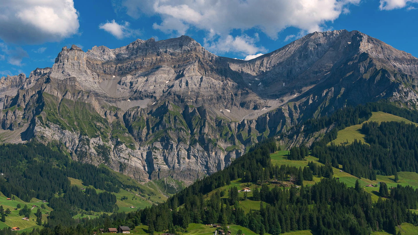
Explore the Oberland Massif during our 6-day long-distance hiking circuit, an immersive adventure in the heart of the majestic Bernese Alps. Thanks to its central location, the massif offers exceptional panoramic views of the surrounding alpine landscapes, creating an unforgettable spectacle that underscores the natural grandeur of this region. Traverse picture-perfect villages that will provide you with an authentic cultural experience. The traditional architecture and picturesque atmosphere of the villages will immerse you in mountain life.
Our circuit offers a total immersion into the diversity of the Oberland Massif, combining majestic glaciers, breathtaking landscapes, alpine fauna and flora, picturesque villages, and unique rock formations. An unparalleled experience in the heart of one of the natural wonders of the Swiss Alps. For this locally rooted tour in the local culture, you'll enjoy a comfortable stay during which your luggage will be transported for you. Transfers are made via local transport, and supplies are obtained in the villages along the route or at mountain huts.
This journey is part of a series of programs we have developed to extend the experience of the Tour du Mont Blanc. Our "light backpack" itineraries, combining exploration and comfort, also take you to the heart of Gran Paradiso National Park in the Aosta Valley or in the Valais Alps with our Chamonix-Zermatt, one of the most beautiful hikes in the Alps.
Group booking
The collective formula associates several people who do not necessarily know each other. It allows for a planned program to benefit from an attractive price on fixed dates. This formula is ideal for people looking for the friendliness of a group.
Dates : See below for the group booking module
Price 2026 : 2410 € per person - based on a minimum of 5 participants
This price includes:
- The organization of the trip
- Thesupervision by a state qualified trekking guide
- Accommodation in mountain hut (dormitory) and hotels (in shared rooms for 2 to 6 people), with half-board (dinner, breakfast and overnight stay). One night is a digital detox hotel is included. Restroom facilities (bathroom and toilets) can be shared collectively in small hotels or inns. For people signing up alone, we cannot guarantee that you will share your room with a person of the same gender.
- Picnic lunches
- Lift passes
- Transfers throughout the hike
- Transportation of one piece of luggage throughout the trek : soft bag, no hard suitcase. Max 15 kg, in case of excess weight, your luggage will not be transported by our provider
This price does not include:
- Transportation to the starting point of the hike
- Accommodation before and after the hike
- Personal expenses: souvenirs, drinks, etc.
- Ski lifts or taxi transfers in case of personal inability to complete the planned stage
- Mandatory repatriation insurance. Cancellation insurance is strongly recommended. (Residents of the following countries—Andorra, Austria, Belgium, Denmark, Finland, France, Germany, Gibraltar, Greece, Ireland, Italy, Liechtenstein, Luxembourg, Monaco, Netherlands, Norway, Portugal, San Marino, Spain, Sweden, Switzerland, and the United Kingdom—can purchase repatriation and cancellation insurance at the same time as their trip registration. This insurance is non-refundable in case of cancellation.)
- Registration fees
- Anything not mentioned under "This price includes"
Private booking
Want to go hiking with family or friends? Want the freedom to choose your departure dates*, enjoy a tailor-made itinerary adapted to your desires, and benefit from guidance specifically suited to your level? Choose the private package!
This is the traditional relationship between a guide and their clients. It allows you to be alone or in a group with your guide, who will respond to your specific needs. The ideal package for realizing your plans, as it guarantees maximum comfort.
Discounted rates based on the number of participants.
*Subject to availability of accommodation.
Contact us for a quote.
Further information
In this section, find all the information about this activity. To prepare your trip effectively, refer to the guides’ tips. They share their expertise and recommendations, ensuring you have a great experience
Meeting point : Meet at 7.30am at the Compagnie des Guides office, 190 Place de l’Eglise, 74400 Chamonix
Level : 5/5 - The Oberland Traverse is a challenging and demanding hiking trail. It involves an ascent of over 3,200 feet and requires an average of 7 to 9 hours of walking per day. The stages are long and strenuous and may take place at high altitudes. Typically, you'll need to carry your own gear for the duration of the trek. This hike takes place on mountain terrain that can be difficult, with challenging sections that require extensive experience in alpine hiking. This program is intended for highly experienced hikers in excellent physical condition.
Itinerary: The guide may need to adjust the itinerary based on weather conditions and/or the physical and/or technical abilities of the group
Guiding policy : 5-12 people per guide. The Compagnie des Guides de Chamonix's guiding policy is one of the strictest in the mountain guiding business. It guarantees the most balanced groups as possible as well as high-quality personalised advice. Registration possible from 16 years of age. Registration is not permitted to anyone under the age of 18 without a legal guardian.
Accommodation :
- During the trip : 5 nights half board in small hotels and moutain hut.
- Before & after the trip : benefit from preferential prices from our partner hotels in Chamonix. If you wish to receive information just ask the Randonnée department.
Documentation :
- Participants must have sports insurance with repatriation cover. We strongly recommend that this also includes cancellation cover. You can take out insurance offering both of these types of cover when you sign up.
- Participants must also take valid ID with them.
Equipment
Weight is a hiker's adversary, so it is crucial to carefully select your equipment as it plays a key role in ensuring the success of your trip
Your gear
-A 40L backpack
-A compact and sturdy travel bag, maximum 15 kg
-A pair of top quality hiking boots
-A pair of telescopic poles
-A hat or cap
-A warm hat
-Category 3 sunglasses
-Breathable long and short-sleeved T-shirts
-A polar fleece
-A warm down jacket
-A Gore-Tex waterproof jacket
-A rain poncho
-A hiking trouser
-A Gore-Tex waterproof trouser
-A short
-A pair of gloves
-Hiking-appropriate socks
-A minimum 2L water bottle
-A pocketknife and a spork
-A flashlight or headlamp
-Sunscreen and lip balm
-A sleeping bag liner
-Toiletry kit, towel, earplugs, and toilet paper
-Minimal personal pharmacy: blister pads like Compeed, medications for common ailments such as diarrhea, constipation, sore throat, headaches, pain, allergies
ID, money for personal expenses
-Spare shoes
-Flip flops for the hut with no luggage access
-Spare clothes as per your preference
Our Rental Partners : You can rent your equipment with our rental shops partners and benefit from special price Sanglard Sports, Ravanel & Co & Concept Pro Shop
Our Equipment Partners : Millet, Dynastar, Julbo, Grivel & Monnet
Itinerary
Day 1
Lake Tseuzier - Iffigenalp
After an early morning transfer that takes us to the Swiss Valais region, we start our hike along the shores of Lake Tseuzier. Quickly, we find ourselves in a typical Swiss alpine meadow, which we ascend with all the peaks of the Valais in the background. Upon reaching the Col de Rawill, we begin our descent amidst waterfalls and lush pastures towards Iffigenalp. Transfer to Simmenfalle, where we will spend the night. Our hotel, which offers a digital detox, will provide us with all the tranquility of nature.
Elevation gain: 2625 feet - descent: 3117 feet - Distance: 8.1 miles
Day 2
Simmenfalle - Ammertepass (2443m) - Engstigenalp
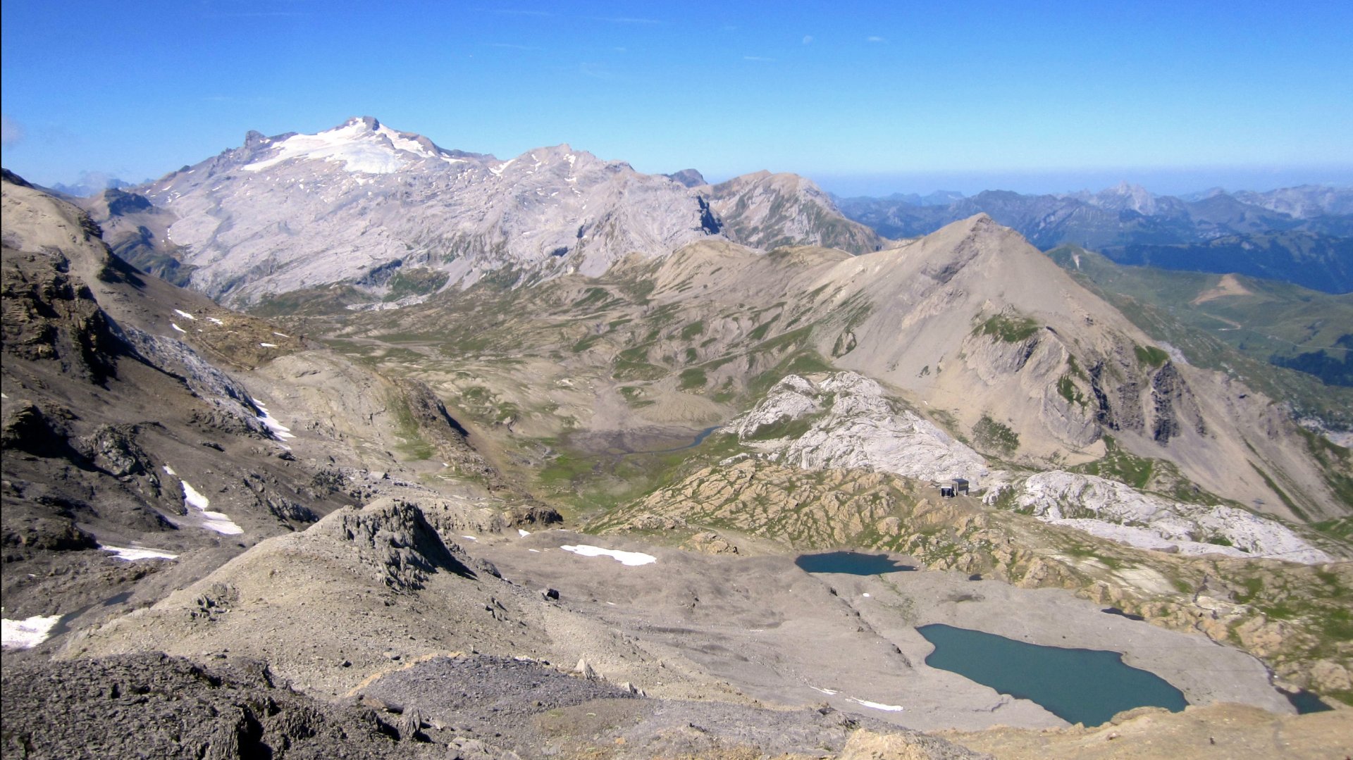
A magnificent day awaits us at the foot of the Wildstrubel, first along the water, then in an increasingly rocky environment as we approach the Ammertepass (8,031 feet). From there, we glimpse the suspended valley that will welcome us for the night at Engstigenalp.
Elevation gain: 4300 feet - descent: 1640 feet - Distance: 6.2 miles
Day 3
Engstigenalp - Kandersteg
We depart from our lofty inn to climb towards the Chindbettipass. Then, we head left along the Entschligegrat ridge to begin the descent towards Kandersteg, along the Alpbach stream.
Elevation gain: 2300 feet - descent: 4600 feet - Distance: 8.7 miles
Day 4
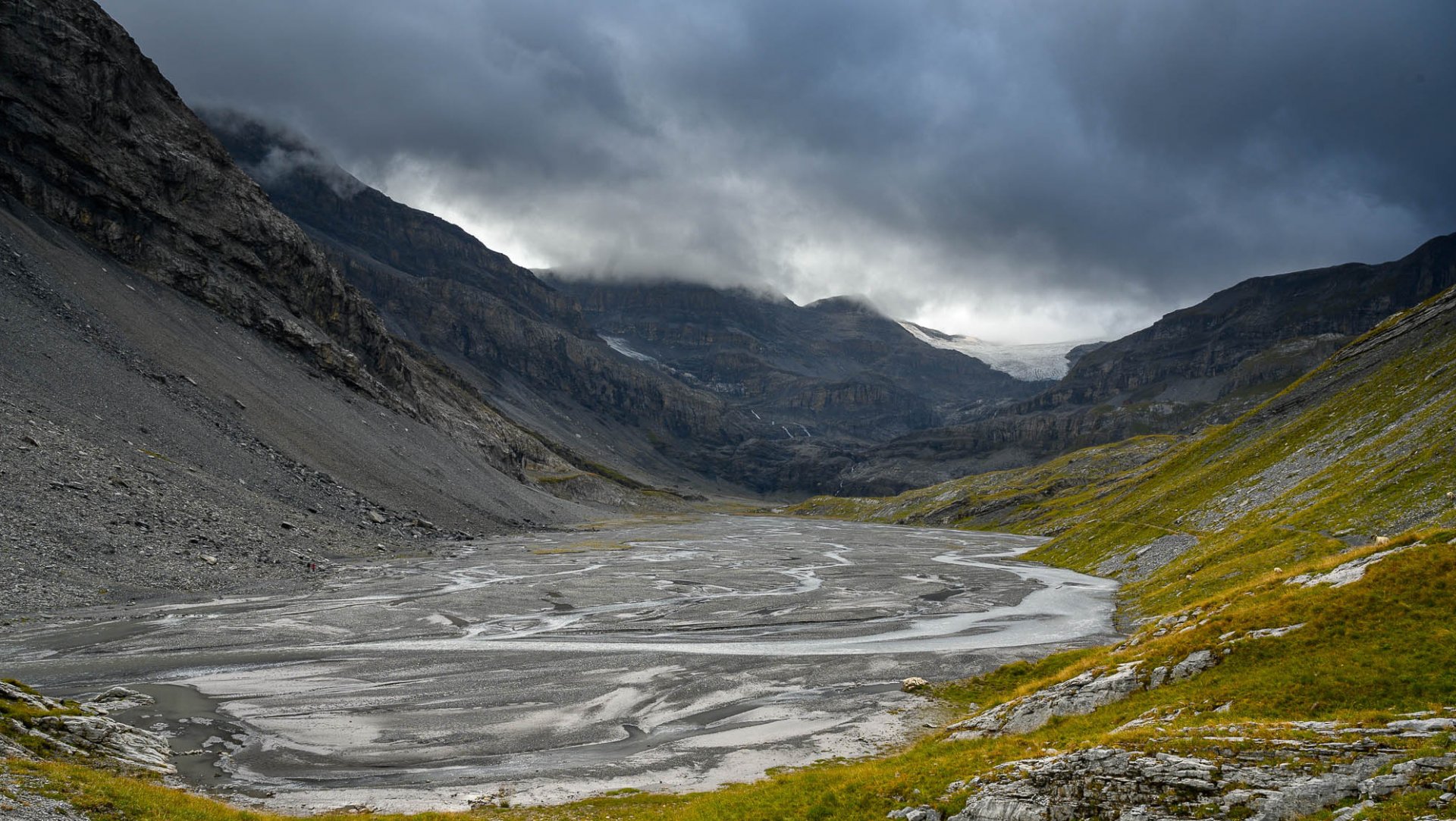
Kandersteg - Kiental
A long ascent punctuated by wonders: starting at Lake Oeschinen, then alpine pastures perfect for a break, followed by the impressive glacial tongues of the Blümlisalpgletscher, and at the Hohtürli Pass, a panoramic viewpoint overlooking the Kandertal and Kiental valleys. The first part of the descent is steep and sustained towards the Kiental pastures. Overnight stay in a mountain farmhouse in Bundalp in dormitory.
Elevation gain: 3700 feet - descent: 3100 feet - Distance: 9.4 miles
Day 5
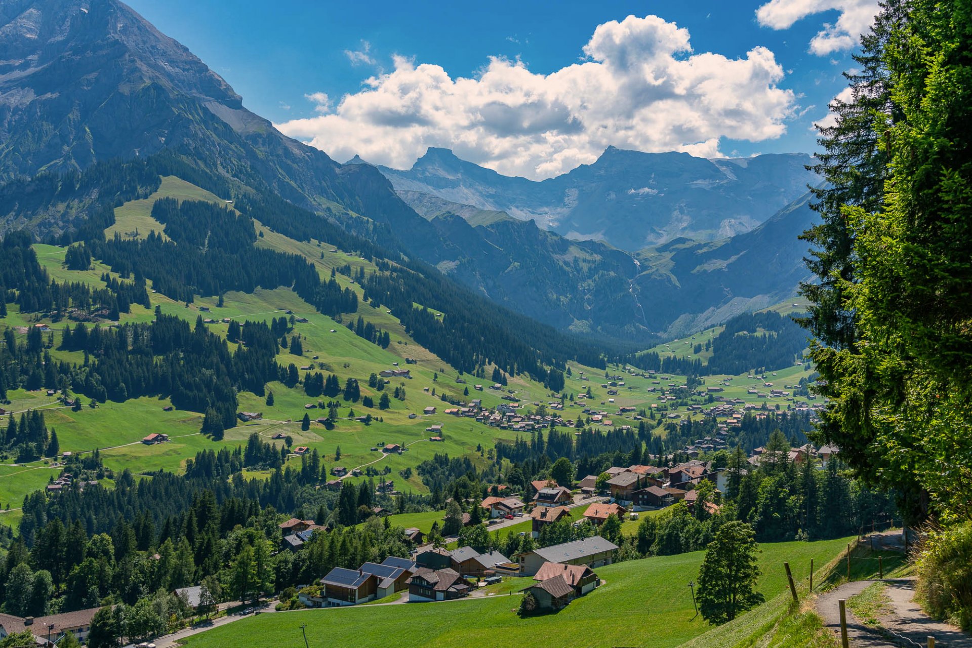
Kiental - Murren
The short descent to the Bundstag Bridge connects to the Sefinenfurgge trail. From the pass, the Jungfrau, Mönch, and Eiger rise majestically. The scenery is breathtaking ! A long descent leads us to the Rotstock alpine pastures and the heights of Mürren. From there, it's just an hour and a half's walk on the famous North Face Trail to reach the upper village where our hostel is located. If the sunset is also present, the experience will be truly enchanting !
Elevation gain: 3950 feet - descent: 2630 feet - Distance: 9.4 miles
Day 6
Murren - Lauterbrunnen
We leave the heights of Mürren and descend by cable car into the Lauterbrunnen Valley. Following the river of the Weisse Lütschine River through this beautiful valley to Sandbach, a stunning ascent begins along the Trummel Gorge. Above the forest, we'll be at the foot of the Jungfrau, the Mönch, and the Eiger ! And how could we end this trip to Switzerland without taking one of those charming little trains ? We descend to Lauterbrunnen using the only local mode of transport.
Return to Chamonix by train.
Elevation gain: 2760 feet - descent: 1610 feet - Distance: 6.3 miles
Booking
Book your activity
Calculate your carbon footprint
Discover the carbon emissions of this activity and add your trip to the meeting point.
CO2 emitted per person for the activity: 53 kg. Learn out more about the footprint calculation of this activity
CO2 emitted per person for the activity: 53 kg. Learn out more about the footprint calculation of this activity
CO2 emitted per person for this activity & journey(s) = 0 kgIn order to limit global warming to +2°C by 2100, the COP-21 agreement stipulates that each human should emit no more than 2t of CO2 per year. According to the French Ministry of Ecology, today European citizens emit an average of 11t per year, and American citizens emit an average of 21t annually., or 5.3€The price for a ton of CO2 is currently 100€ in the European Union to offset.
Find out more about our zero impact strategy.
x